
This past winter season my community - and my home - were flooded with over 4 feet of water for several days. I was forced to evacuate to higher grounds to the neighboring town, Palmar Norte. Although I had tried to stack up all of my clothes and other accessories on top of my table and dresser, unfortunately when the water entered the house there were strong currents that knocked the table over, ruining some of my things and muddying up others (like clothes).
Although I could spend much time upset about what I lost, I realize that my problems were very little in comparison with those who had lost things more valuable, who couldn’t stack up their refrigerator or washing machine before the water came rushing in at 4:30 AM. I also think about all of the small businesses in the center of Cortés that lost much of their inventory and had to start again from scratch.
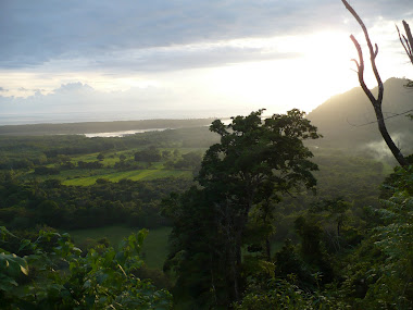
Interestingly, not only were peoples’ lives affected by the floods of this winter, so too was the environment and its habitat. The largest river in Costa Rica, El Terraba, which starts in the mountains of Talamanca, passes through my community. Furthermore, many winding estuaries and mangrove swamps branch off from the river. After this year’s winter storm, several local community members have said that the river, estuaries, and mangroves have changed dramatically.
One particular community member, and close friend, that has been fishing in the Terraba for over 40 years has been helpful in explaining to me how much the area has changed after this past winter. Land masses that were once on one side of the river are now located on the other side due to the force of the water. Canals and estuaries that once were fished and traveled by locals by boat, now no longer exist, and are filled with mud and sand carried by the river.
My friend has been directly affected by these changes. His finca, which is backed by mangrove swamp and is only reachable by boat, was also altered. Before, he was able to travel to his finca to work at any point of the day – low tide or high tide. However, after the tropical storm, he is only able to arrive by boat during high tide, when the estuaries and river have more water. When the tide is low, the estuary is a muddy lagoon and does not have sufficient water to enter. Furthermore, the mangrove swamp that backs his farm was filled with sand, drying out and killing most, if not all plant life.
Rancho Quemado, which has always been a pasture which rolls along the river - and a popular point for community members to fish - was left unrecognizable. I had gone several times before the winter storm, and the pasture was quite swampy, with tall grass and a mud-rich soil. Now, the pasture is almost a sandy beach. Instead of cattle, the owner of this farm now plants rice, as grass doesn’t grow well in this terrain.
Most interestingly, Ranch Quemado has historically been the place where community members “cangrejear” - a special time of year toward the end of May when the cangrejos (crabs) come out of their caves in such large quantities that people can fill sacks with crabs. This has been a Ciudad Cortés tradition throughout the entire history of the town. This year, however, the “cangrejeada” did not happen.
As this type of cangrejos’ habitat is mud, Rancho Quemado no longer houses the thousands of crabs that it once held. It is now sand-filled. I was able to make the trip with my friend this May in search for cangrejos. Several others also had the same idea. We passed many people in bicycle en route to Ranch Quemado. All were quite disappointed and confused as to why there were no cangrejos this year. The answer lies in the fact that the past winter storm affected and changed everything; from peoples’ lives, to the community, to the environment.